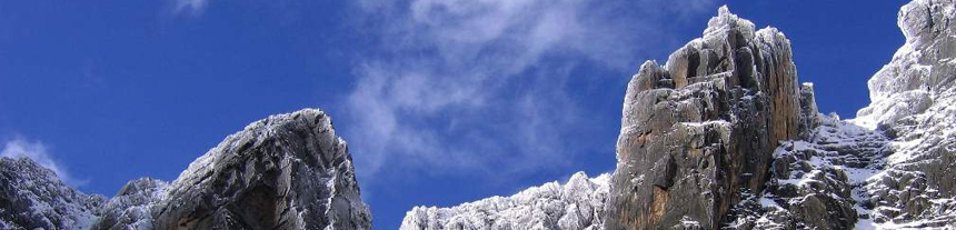
Rwenzori Mountains National Park known as the “Mountains of the Moon” is situated in Western Uganda in the East African Rift Valley. The park straddles the Democratic Republic of Congo and its conservation area known as Virunga National Park. The mountain is the third tallest in Africa rising more than 16,700 feet above sea level and its highest peaks rise above the clouds and are permanently snowcapped. The Rwenzori Mountain ranges are higher than the Alps and their glaciers are one of the sources of the longest river on earth, the River Nile.
Margherita Peak is the highest peak on the ranges making it the 3rd highest peak in Africa together with its twin peak, Mount Stanley, which is located in the park. The 4th and 5th highest peaks, Mount Speke and Mount Baker are also within the park. The mountain ranges were first noticed in CE 150 by Alexandrian geographical researcher and photographer, Pletomy when he described a stunning mountain that he named the “mountain of the moon.” Later in 1899, English explorer, Henry Morton Stanley, was as spellbound as Pletomy when he beheld the ranges and named them the “Cloud Mountains.”
The region’s glaciers, waterfalls, and lakes make it one of Africa’s most beautiful alpine areas. The park has many natural habitats of endangered species and a rich and unusual flora comprising, among other species, the giant heather. The Rwenzori Mountains are the highest and most permanent sources of the River Nile and constitute a vital water catchment. Their multitude of fast-flowing rivers, magnificent waterfalls, and stratified vegetation make the property exceptionally scenic and beautiful. The mountains are well-known for their unique alpine flora which includes many species endemic to the Albertine Rift in the higher altitude zones including giant heathers, groundsels, and lobelias.
The Mount Rwenzori National Park borders several national parks in Uganda with Rwenzori being at the center. It borders both Semuliki National Park and Kibale National Park in the North, and Queen Elizabeth and Bwindi National Park in the South.
A safari to Mt Rwenzori National Park can be combined with Kibale National Park, Lake Mburo National Park, Murchison Falls National Park, Semuliki National Park, Queen Elizabeth National Park, and Bwindi Impenetrable National Park, or Mgahinga National Park for a gorilla trekking Adventure.
The Rwenzori National Park, which is the conservation area for the mountain, is a UNESCO World Heritage Site and covers almost 1000 sq. km and strides across the districts of Kabarole, Kasese, and Bundibudyo. It includes most of the center and the eastern half of the mountain and is known for its beautiful plant life coupled with waterfalls, glaciers, and a lot of other unique mountainous vegetation. The park has glaciers, snowfields, and waterfalls and has been portrayed as one of the mainly attractive Alpine areas around the world.
Wildlife
Two mammals are distinct to the range, the Rwenzori climbing mouse and the Rwenzori red duiker, as are 19 of the 241 known bird species. Despite this, this is one of Uganda’s less-visited national parks, so nature lovers wanting to escape the safari crowds should put it on their list. The national park hosts 70 mammals and 217 bird species including 19 Albertine Rift endemics, as well as some of the world’s rarest vegetation.
What to do
Mountain/Volcano Climbing in the Rwenzori Mountains
The Rwenzoris are a world-class hiking and mountaineering destination. A nine- to twelve-day trek will get skilled climbers to the summit of Margherita – the highest peak – though shorter, non-technical treks are possible to scale the surrounding peaks. Keen climbers can choose between two scenic routes to the top of the Rwenzoris – Africa’s third-highest peak! The trails pass glacial lakes, gorgeous viewpoints, dramatic mountain passes, and lush valleys.
Hiking and Nature Walks in the Rwenzori Mountains
Follow the trails up to Lake Mahooma and Buraro chimp forest; through the communities of Kichamba to the Karangura ridge; and the Bundibugo area through Bwamba pass. The communities of Ruboni and Turaco View also offer guided forest walks of various lengths just outside the park.
Kilembe Trail: The recently reopened Kilembe Trail ascends the southern slopes of the Rwenzori from a trailhead at Kilembe near the town of Kasese. The route along the lovely Nyamwamba Valley passes glacial lakes and some stunning viewpoints before joining the Central Circuit at Lake Kitandara. The standard route scales Mount Baker though the scenery makes shorter treks rewarding enough.
Cultural Encounters in the Rwenzori Mountains
Walk with Bakonzo villagers through their homesteads in the foothills of the Rwenzoris as they demonstrate their daily activities, from tending to their animals and crops to preparing meals with the freshest ingredients. See cultural dances, and traditional costumes and hear their fascinating folklore. Bakonjotribe is the main inhabitant of this region and carries out cultivation on the slope of the mountains. Other tribes include the Bwanba on the Bundibugyo side of the ranges and the Batooro in Fort Portal.
Ruboni Community Camp
Discover the peaceful farming village of Ruboni, home to around 2,000 Bakonzo, in the foothills of the Rwenzoris. Walk with the villagers as they demonstrate their daily activities, from tending to their animals and crops to preparing meals with the freshest ingredients. Meet the blacksmith, traditional healer, basket weavers, and storytellers, and enjoy a vibrant dance performance accompanied by lively drumming.
Alternatively, your guide will lead you along the rocky Mubuku River. Ruboni means clear water in the local language of Lukonzo, and you will follow this crystal-clear stream, passing villagers carrying crops and wood. As the trail winds upwards, your guide will point out many colorful native birds such as the Rwenzori Turaco, tiny sunbirds, and Cinnamon-chested Bee-eaters. There are also chameleons, squirrels, and vervet monkeys.
Look out for Baker and Portal Peaks rising above the forests. On a clear day, the snowcapped Margherita Peak is also visible – a truly spectacular sight.
Rwenzori Turaco View Camp Site
The tiny village of Mihunga faces the craggy, snow-capped peaks of the Rwenzori Mountains. The Bakonzo tribe has lived here for over 300 years with no electricity or running water, and this community has adapted its way of life to the climate and steep green hillsides of the Rwenzori foothills.
Mihunga‘s community tourism group, Turaco View, takes visitors on a cultural tour of the village. This includes a demonstration by a traditional healer, whose herb-based concoctions are believed to cure many ailments. There is also a trip to the village school, a crafts demonstration, and a lively dance performance.
Visitors can also choose to walk with a local guide through the surrounding forests. They may be lucky enough to spot brightly colored turacos in the forest canopy. The expert guides will be able to point out other species such as bee-eaters, sunbirds, and playful black-and-white colobus monkeys.
Bulemba – Ihandiro Cultural Trail
Follow this fascinating six to seven-hour trail through the holy valley and other sites of great cultural significance to the Bakonzo tribe. A community guide will introduce you to the traditional healer, explaining his powers, known as muhima; and to the local blacksmith, who will reveal the spiritual significance of the traditional Bakonzo stool. Basket weaving and firemaking skills are also demonstrated along the route.
The trail then takes you across the Kamusonge River whose waters are believed to be sweet and quick to quench the thirst. There is a break in a hut to enjoy the glorious mountain views and shelter from the equatorial sun, before embarking on the final hour-long walk to the museum, thatched in the traditional Konzo style. On display are implements used during the Rwenzururu struggle, traditional dress, and other items of historical and cultural importance to the people of the Rwenzoris.
Birding in the Rwenzori Mountains
Birding opportunities are greatest in the montane forest. Over 217 bird species including 19 Albertine Rifts can be spotted in this area which includes Bee-eaters, robins, sunbirds, and barbets are some of the 217 species found in Rwenzori Mountains National Park. Other species to watch out for include the Rwenzori Turaco and Long-eared Owl; while higher up on the slopes, Bearded Vultures, Swifts, and Black Eagles may be seen circling for prey.
Accommodations.
Do not get worried about where to sleep, many hotels and lodges exist in this region due to it being a tourism area. A number of lodges surround the park and the Kasese town. You can also find lodging near Queen Elizabeth National Park. The hotel varies from budget to luxury lodgings. There is something that suits your interest and budget here for everyone.
Getting Here!
From Kampala – Uganda
Rwenzori Mountains National Park lies a few kilometers north of the equator on the Uganda-Congo border. The park trailhead at Ruboni can be reached from Kampala from the North via Fort Portal (375km) or the south passing through Mbarara and Queen Elizabeth National Park (450km). Nyakalengija is 17km off the Kasese-Fort Portal road and 25km north of Kasese town.
Charter flights to Kasese can be arranged from Kampala (Kajjansi) or Entebbe International Airport.
From Kigali – Rwanda.
Rwenzori Mountains National Park can be accessed from Kigali via the Katuna border and through Ntungamo to Kasese which is roughly a 5-hour drive journey from Rwanda.
For more information or packages about Mount Rwenzori National Park, kindly contact our office by email: sales@rwandaecocompany.com or info@rwandaecocompany.com, you can also make a phone call: +250788439357 or +250788508228.